
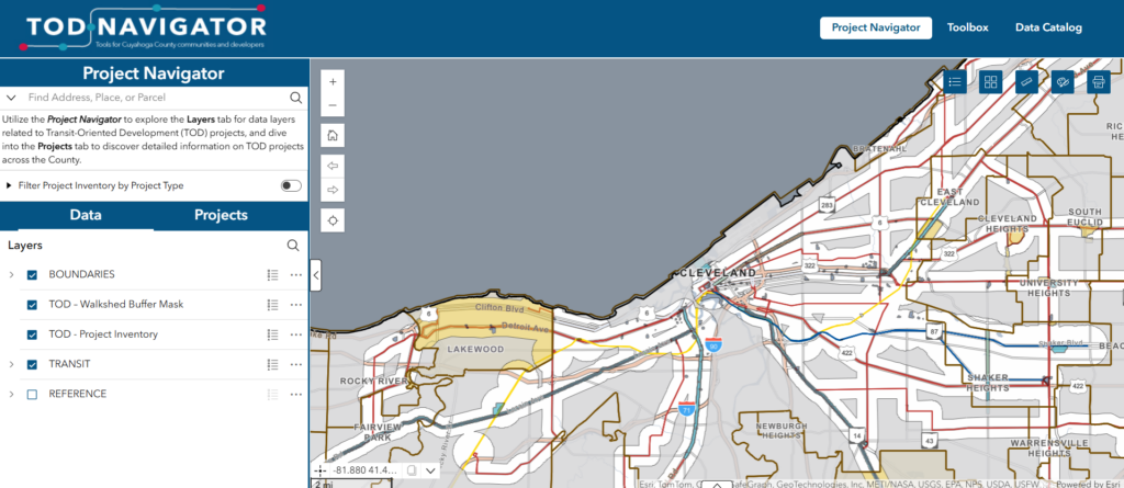
The TOD Navigator is an online mapper that features recent TOD projects taking place throughout Cuyahoga County and is updated quarterly. The TOD Navigator allows individuals to see the different types of TOD projects occurring through the County, their location, their details, and progress.
The TOD Navigator includes data on TOD developments, infrastructure improvements, plans, and zoning changes. Data is based on local input, review of fiscal office Delta Track data, and review of planning commission agendas for relevant communities.
The TOD Navigator is in beta form, and data is still being analyzed and added. If you see missing data, incorrect data, or have questions about what is being shown, please contact County Planning at info@countyplanning.us or use the form at the end of this page.
Navigator
Try the TOD Navigator today!
Inclusion Matrix
Items included in the online mapper must meet certain criteria to be eligible for inclusion. The matrix below outlines the decision-making process for determining whether an item qualifies for inclusion in the mapper.
| DEVELOPMENTS | PLANNING | ZONING | INFRASTRUCTURE | |
|---|---|---|---|---|
| Definition | Transit-oriented construction projects along TOD corridors (ex: Intro) | Publicly led planning projects for new developments, land uses, or infrastructure (ex: Broadway TOD Plan) | New zoning regulations that support transit-oriented development (ex: South Euclid TOD Zoning) | Major transportation infrastructure projects that incorporate significant transit infrastructure (ex: W25th St BRT) |
| Current Inventory | Projects have been identified going back to 2019. Future projects will be added to this inventory. | Projects have been added that have been identified. Future projects will be added to this inventory. | Projects have been added that have been identified. Future projects will be added to this inventory. | Projects have been added that have been identified. Future projects will be added to this inventory. |
| Criteria | Must conform to TOD principles: close to the street, multiple stories, parking located to side/rear, TOD-friendly use/mixed use Must be new construction or significant change of use toward TOD-friendly use, including from long-term vacant to useable buildings (not renovation or reinvestment in same use) Only projects adding more than $1 million in added building value were considered; residential projects must have at least six residential units Development projects qualify as being in the pipeline when they have approval from the local planning authority | Must be a TOD-friendly development plan, TOD area plan, or include land uses around a TOD corridor Plans for infrastructure that do not include major land use elements go to Infrastructure | Must be in mixed-use or commercial districts Must conform to TOD principles: close to the street, multiple stories, parking located to side/rear, front door, TOD-friendly use/mixed use | Must include significant transit infrastructure: dedicated bus lanes, major transit stop or shelter Plans that identified various infrastructure and land use projects go to Planning |
Updates and Additions
County Planning updates data on the TOD Navigator quarterly through local research, reviews of planning commission agendas, and data coming from the Cuyahoga County Fiscal Office.
Do you see a development, infrastructure improvement, plan, or zoning change that is missing? Fill out the form below to let us know about the project:
Disclaimer
County Planning’s TOD Navigator is intended for reference purposes only. County Planning assumes no responsibility or liability for any errors or omissions in the content of this mapping tool. The information contained within is provided ‘as is’ with no guarantees of completeness, accuracy, usefulness, or timeliness.