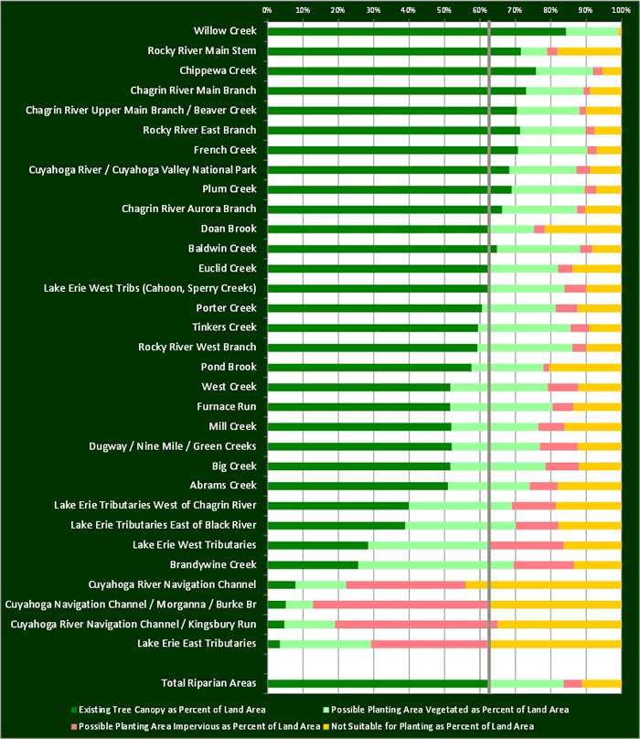
Land areas that are adjacent to rivers, streams, lakes, and wetlands are perhaps the most critical zones for tree planting.
As part of its Greenspace planning efforts, the Cuyahoga County Planning Commission collaborated with a number of partners, including Cleveland Metroparks and Chagrin River Watershed Partners to develop “modeled” riparian corridors. Riparian buffers range in size from 25 feet for small streams to 300 feet for larger drainage areas, including the Lake Erie shoreline.
When these riparian zones are summarized by subwatersheds, Existing Tree Canopy coverage varies widely within the County’s riparian zones. As a whole, 65% of the county’s riparian zones are covered by Tree Canopy—well above the county’s 37.6% average. Much of that Tree Canopy can be attributed to areas within the Cleveland Metroparks (e.g., Rocky River Reservation) and the Cuyahoga Valley National Park. More problematic, however, are individual subwatersheds, whose riparian areas have Tree Canopy that cover less than 50% of its area.
Figures
Tree Canopy metrics for riparian zones, summarized by subwatershed