Here are definitions and descriptions of key terms, phrases, and acronyms used throughout these pages.
What is a Greenway?
A Greenway is a dedicated, linear corridor that provides opportunities for recreation and alternative transportation, and, in some places, access to natural features.
Some greenways integrate off-street trails with natural features such as rivers and wildlife habitat, such as Cleveland Metropark’s Emerald Necklace. Others are developed from vacated lots, roads, and railway corridors such as Cleveland’s Redline Greenway.
What is an Urban Trail?
An Urban Trail is a dedicated civic infrastructure that provides alternative-mode local community connections to jobs, civic buildings, cultural features, and open space assets.
Urban Trails, like sidewalks, are typically linear connections along existing street corridors. These facilities can be built both on-street (e.g. buffered bike lanes) or off-street (e.g. a multi-use trail or side path.) The Towpath Trail, the Cleveland Lakefront Bikeway, the Detroit Superior Bridge Bike Lane, and the Lorain Ave. Cycletrack are examples of urban trails.
What are the benefits of Greenways and Urban Trails?
As a tool for improving mobility, health, and the environment, Greenways and Urban Trails can provide a wide range of benefits, particularly when designed for all ages and abilities. They:
- Increase mobility and transportation options by connecting residents to jobs, commercial areas, institutions, and other destinations.
- Improve community health through active living by creating attractive, safe and accessible places to walk, bicycle, hike, and run.
- Generate economic activity through increased property values, tourism, and as an attractor for businesses and residents.
- Improve air quality and encourage reduced car travel by providing accessible and safe transportation alternatives.
- Protect and restore natural habitats that enhance air quality, help balance atmospheric carbon, manage storm water surges and filter runoff.
- Encourage cultural awareness and community identity by connecting residents and tourists to local history, heritage, and cultural institutions.
What is an All Ages and Abilities Network?
An All Ages and Abilities Network accommodates all users. The Cuyahoga Greenways will be intentionally designed trails, bicycle facilities, and pedestrian amenities that offer comfort and safety with an accessible and welcoming network for all non-vehicle users regardless of age or ability. The Cuyahoga Greenways welcome users to an easy-access network for their walking or cycling needs.
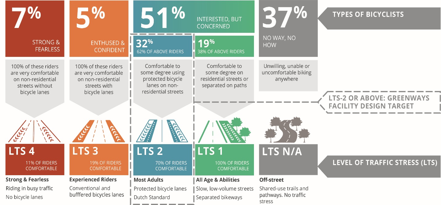
One key to encouraging more active transportation use is to better understand the diverse types of individuals that exist in a community and how their comfort and safety can be prioritized, instead of marginalized, when designing and building pedestrian and bicycle infrastructure. For example, a national survey of people living in the 50 largest metropolitan areas in the U.S. found that only 5% of an area’s population are comfortable biking on nonresidential streets when bike lanes are present. Similarly, the survey found that 51% of the population might be willing to bike on separated trails or protected bike lanes if such facilities exist, while 37% are unwilling, unable, or uncomfortable biking anywhere. Knowing what types of facilities are needed to make each individual route in the network more comfortable for the broadest range of users is a key component and long-term goal for the Cuyahoga Greenways.
What is Level of Traffic Stress?
One of the planning and engineering tools available for addressing how best to accommodate these different types of cyclists is a method called ‘Level of Traffic Stress’ (LTS). LTS considers a range of factors for biking within a roadway corridor to determine how ‘stressful’ the riding experience might be for an average rider. Factors that influence the Level of Traffic Stress score include the speed and volume of vehicular traffic, the number of travel lanes, the size and complexity of intersections, and the types of bicycle facilities (if any) provided. LTS 4 roads are considered the most stressful, while LTS 1 routes are consider the least stressful, and more conducive to riders of all ages and abilities.
Level of Traffic Stress data can be easily utilized by the Cuyahoga Greenways network to help determine what facilities are needed to create a comfortable, accessible All Ages and Abilities Network in as many locations as possible. For example, LTS 3 corresponds to conventional bike lanes on major roadways, which only appeals to a small group of “strong and fearless” and/or “enthused and confident” riders. If the existing bike lanes could be upgraded, or new protected bike lanes added, the level of traffic stress on an LTS 3 route would drop to LTS 2 or 1. This could create a route that most adults would have some level of comfort using, possibly leading to increased ridership.
As new, proposed Cuyahoga Greenways projects move from planning and design to construction and operation, it is important to emphasize and follow the recommendations from the Level of Traffic Stress methodology. LTS 1 and 2 facilities such as multi-use trails, side paths, and protected bike lanes should be the LTS goal for all projects, especially those significant projects identified as Critical Gap and/or Regional Links.
What are the Different Types of Routes identified in the Cuyahoga Greenways Plan?
The Priority Project List from the Cuyahoga Greenways Plan identifies some key routes for the region and presents them into three distinct categories.
- Critical Gaps: Critical Gaps are short sections of future greenways or urban trails that fill “gaps” in the existing regional trail network. These gaps typically connect to existing trails or other non-motorized facilities at both ends. Intended to be the backbone of the regional network these future connections should match the existing network that ties them together and be designed to accommodate an LTS score of 1, creating an All Ages and Abilities link.
- Regional Links: Regional Links are longer sections of the regional network. These routes typically connect existing regional trails on at least one end, linking major population centers, employment hubs, recreational anchors, or even trails and communities outside of Cuyahoga County. Intended to create new multi-jurisdictional connections, these facilities should ideally be designed to accommodate a LTS score of 1 or 2 to allow the broadest spectrum of residents to take advantage of these connections.
- Key Supporting Routes: Routes that were found through public engagement or technical evaluation that otherwise serve as significant local links are identified as Key Supporting Routes. Intended to increase or create new local connections, these facilities might consist largely of bicycle boulevards on low traffic or quiet streets that produce additional low stress connections to neighborhood destinations or the larger regional network.
The projects identified in the Cuyahoga Greenways Plan are, in most cases, proposed at a conceptual level, serving as a placeholder or guide for a future facility. Every route shown in the Greenways Plan is considered a meaningful connection in the county and should be built to the lowest level of traffic stress (LTS) possible. Realization of a fully inclusive All Ages and Abilities Network for all neighborhoods will require a strong commitment to this goal and necessitate meaningful coordination, collaboration, and creativity when building these new facilities.