Cuyahoga County is intersected by 3 major watersheds: the Rocky, Cuyahoga, and Chagrin. In addition, much of the County drains directly to the shores of Lake Erie. Within those major watersheds are 32 smaller subwatersheds (Figure 8), ranging in size from 200 acres to more than 20,000 acres.
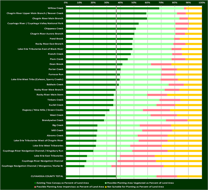
Research by Goetz et al. (2003) indicates that watersheds with 37% tree canopy can be categorized as “fair” in a stream health rating; watersheds with 45% tree canopy can be categorized as “good.” While the countywide tree canopy overage is 37.5%, the extent within each subwatershed varies widely.
Figures:
Tree canopy metrics summarized by watershed
Existing tree canopy summarized by subwatershed

Possible planting area summarized by subwatershed

Tree canopy metrics summarized by subwatershed
| Existing Tree Canopy | Possible Planting Area Vegetated | Possible Planting Area Impervious | Not Suitable for Planting | Rank | |||||||
|---|---|---|---|---|---|---|---|---|---|---|---|
| Name | Total Land Cover, Excluding Water (Acres) | Acres | Percent | Acres | Percent | Acres | Percent | Acres | Percent | Existing Tree Canopy | Existing Impervious |
| Abrams Creek | 6,480.4 | 1,463.2 | 22.6% | 1,965.3 | 30.3% | 1,434.1 | 22.1% | 1,644.6 | 25.4% | 26 | 9 |
| Baldwin Creek | 6,345.9 | 2,488.6 | 39.2% | 2,342.9 | 36.9% | 717.3 | 11.3% | 854.0 | 13.5% | 16 | 20 |
| Big Creek | 23,985.3 | 5,569.0 | 23.2% | 7,491.1 | 31.2% | 5,548.2 | 23.1% | 5,456.6 | 22.7% | 24 | 6 |
| Brandywine Creek | 213.9 | 60.0 | 28.0% | 97.5 | 45.6% | 34.0 | 15.9% | 22.8 | 10.7% | 23 | 17 |
| Chagrin River Aurora Branch | 5,419.4 | 2,771.5 | 51.1% | 1,657.6 | 30.6% | 397.0 | 7.3% | 682.7 | 12.6% | 6 | 29 |
| Chagrin River Main Branch | 27,935.7 | 16,834.9 | 60.3% | 6,706.4 | 24.0% | 1,785.1 | 6.4% | 2,919.5 | 10.5% | 2 | 30 |
| Chagrin River Upper Main Branch / Beaver Creek | 1,477.4 | 890.3 | 60.3% | 340.3 | 23.0% | 98.8 | 6.7% | 178.4 | 12.1% | 3 | 28 |
| Chippewa Creek | 11,331.2 | 5,861.6 | 51.7% | 3,315.4 | 29.3% | 995.5 | 8.8% | 1,220.2 | 10.8% | 5 | 26 |
| Cuyahoga Navigation Channel / Morganna / Burke Br | 3,047.7 | 420.3 | 13.8% | 610.8 | 20.0% | 1,186.6 | 38.9% | 870.1 | 28.6% | 32 | 1 |
| Cuyahoga River / Cuyahoga Valley National Park | 18,319.8 | 9,934.7 | 54.2% | 5,001.7 | 27.3% | 1,857.1 | 10.1% | 1,781.3 | 9.7% | 4 | 25 |
| Cuyahoga River Navigation Channel | 5,266.8 | 813.6 | 15.4% | 1,248.0 | 23.7% | 1,540.0 | 29.2% | 1,837.2 | 34.9% | 31 | 2 |
| Cuyahoga River Navigation Channel / Kingsbury Run | 5,937.8 | 1,204.3 | 20.3% | 1,714.8 | 28.9% | 1,548.8 | 26.1% | 1,510.9 | 25.4% | 29 | 5 |
| Doan Brook | 6,238.9 | 2,608.8 | 41.8% | 1,319.8 | 21.2% | 948.4 | 15.2% | 1,409.4 | 22.6% | 12 | 13 |
| Dugway / Nine Mile / Green Creeks | 15,017.5 | 4,808.0 | 32.0% | 3,693.9 | 24.6% | 3,013.2 | 20.1% | 3,526.5 | 23.5% | 21 | 8 |
| Euclid Creek | 13,268.7 | 4,641.5 | 35.0% | 4,236.8 | 31.9% | 1,835.1 | 13.8% | 2,623.3 | 19.8% | 20 | 14 |
| French Creek | 3,923.4 | 1,886.0 | 48.1% | 1,203.8 | 30.7% | 288.1 | 7.3% | 576.9 | 14.7% | 10 | 27 |
| Furnace Run | 1,873.4 | 756.7 | 40.4% | 574.8 | 30.7% | 205.1 | 10.9% | 366.3 | 19.6% | 14 | 23 |
| Lake Erie East Tributaries | 8,068.0 | 1,260.5 | 15.6% | 1,963.0 | 24.3% | 2,097.0 | 26.0% | 2,820.1 | 35.0% | 30 | 3 |
| Lake Erie Tributaries East of Black River | 599.5 | 294.7 | 49.2% | 173.3 | 28.9% | 44.2 | 7.4% | 91.0 | 15.2% | 8 | 21 |
| Lake Erie Tributaries West of Chagrin River | 6,311.1 | 1,415.2 | 22.4% | 1,965.2 | 31.1% | 1,353.5 | 21.4% | 1,596.3 | 25.3% | 27 | 7 |
| Lake Erie West Tribs (Cahoon, Sperry Creeks) | 12,826.0 | 5,082.5 | 39.6% | 3,865.6 | 30.1% | 1,641.5 | 12.8% | 2,267.7 | 17.7% | 15 | 16 |
| Lake Erie West Tributaries | 5,915.0 | 1,299.4 | 22.0% | 1,499.7 | 25.4% | 1,379.0 | 23.3% | 1,741.4 | 29.4% | 28 | 4 |
| Mill Creek | 12,381.3 | 2,866.0 | 23.1% | 4,105.1 | 33.2% | 2,749.6 | 22.2% | 2,717.0 | 21.9% | 25 | 10 |
| Plum Creek | 1,142.0 | 523.1 | 45.8% | 370.3 | 32.4% | 118.4 | 10.4% | 139.4 | 12.2% | 11 | 22 |
| Pond Brook | 1,115.5 | 561.0 | 50.3% | 345.5 | 31.0% | 47.7 | 4.3% | 186.2 | 16.7% | 7 | 31 |
| Porter Creek | 4,146.8 | 1,681.6 | 40.6% | 1,254.8 | 30.3% | 477.9 | 11.5% | 767.0 | 18.5% | 13 | 18 |
| Rocky River East Branch | 20,559.9 | 10,115.9 | 49.2% | 6,289.7 | 30.6% | 1,842.7 | 9.0% | 2,523.2 | 12.3% | 9 | 24 |
| Rocky River Main Stem | 9,535.4 | 3,408.0 | 35.7% | 2,388.0 | 25.0% | 1,432.2 | 15.0% | 2,477.3 | 26.0% | 18 | 12 |
| Rocky River West Branch | 15,769.5 | 5,817.9 | 36.9% | 5,729.9 | 36.3% | 1,733.7 | 11.0% | 2,628.5 | 16.7% | 17 | 19 |
| Tinkers Creek | 24,631.8 | 8,677.5 | 35.2% | 8,388.5 | 34.1% | 3,804.3 | 15.4% | 3,960.6 | 16.1% | 19 | 15 |
| West Creek | 12,100.6 | 3,499.2 | 28.9% | 4,096.6 | 33.9% | 2,363.6 | 19.5% | 2,247.4 | 18.6% | 22 | 11 |
| Willow Creek | 263.8 | 180.9 | 68.6% | 48.3 | 18.3% | 3.7 | 1.4% | 31.0 | 11.8% | 1 | 32 |
| CUYAHOGA COUNTY TOTAL | 291,510.5 | 109,688.3 | 37.6% | 86,032.2 | 29.5% | 44,560.2 | 15.3% | 53,912.3 | 18.5% | ||
For downloadable spreadsheets and GIS data, see the Downloads page.
For an interactive version, explore the Land Cover/Tree Canopy layers in our Greenprint Viewer.
