
The Transit-Oriented Development (TOD) Zoning Study aims to improve zoning regulations and governmental policies in order to attract more transit-oriented development to key corridors in Cuyahoga County.
Recent Updates
TOD Loan Program
On August 25, 2025, the Cuyahoga County Department of Development launched the Transit-Oriented Development (TOD) Loan Program, which is designed to catalyze mixed-use, high-density development projects located near high-frequency public transit. The County offers subordinated long-term, fixed-rate gap financing at below-market rates to developers and businesses that may have difficulty securing all capital necessary for such urban redevelopment projects.
Development Trends on TOD Corridors
The 2026 edition of the Development Trends on TOD Corridors report found that more than $1.5 billion worth of transit-oriented development has been constructed in Cuyahoga County in the last seven years. This report analyzes new developments of greater than $1 million in added building value between 2019 and 2025, and it focuses on 22 TOD corridors where frequent transit runs.
 On August 25, 2025, the Cuyahoga County Department of Development launched the
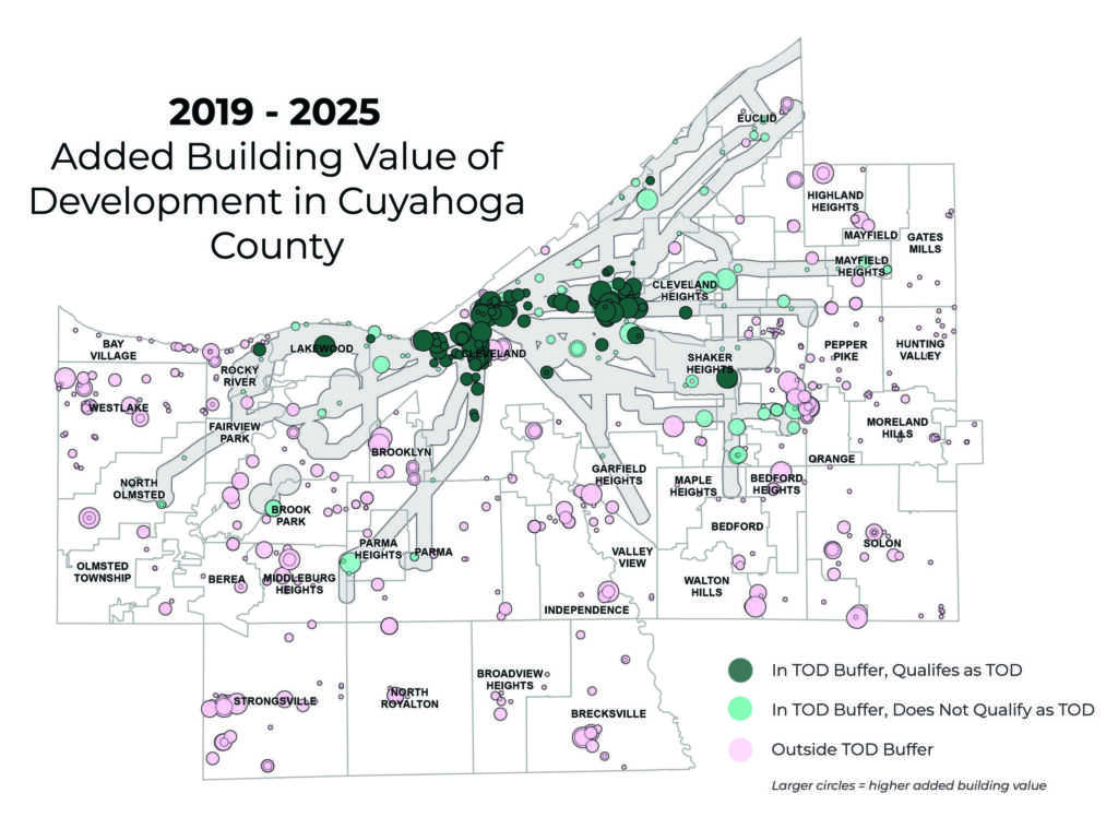
County Planning and GCRTA have partnered on the TOD Zoning Study—in collaboration with the Cities of Cleveland, Shaker Heights, Fairview Park, and Cleveland Heights; as well as other local communities, agencies, and entities—to encourage and support those seeking to build transit-oriented developments along major transit corridors.
The TOD Zoning Study
The TOD Zoning Study is a four-part initiative that aims to understand and offer improvements to local zoning and land use strategies in a way that supports additional transit-oriented development. The four initial phases of the TOD Zoning Study are outlined below.
- State of TOD in Cuyahoga County
Define and describe the importance of TOD; identify and quantify TOD corridors and local TOD examples (also available as an interactive overview). - Analysis of TOD Zoning
Analyze whether existing zoning along transit lines allows TOD and identify target areas for future investment - Best Practices & Model TOD Zoning
Develop best practices and model zoning for TOD that can be adopted by individual municipalities - TOD Financing Strategies
Identify TOD financing mechanisms and incentives used in other communities
Additional work has emerged from the initial phases of the TOD Zoning Study. The Development Trends and the TOD Navigator provide data on TOD locally and are updated periodically. Additional Studies and Resources contain supplemental reports, presentations, and additional resources that help illustrate the importance and impact of TOD locally and among peer communities.

The TOD Zoning Study in the News
- New zoning overlay to transform Fairview Park's commercial corridor
Sun Post Herald
February 4, 2026 - New Cuyahoga County loan program aims to spur growth along public transit lines
Cleveland.com
August 26, 2025 - County offers loans to build near transit
NEOtrans Blog
August 26, 2025 - Cuyahoga County announces loans to boost transit-oriented development
Ideastream Public Media
August 25, 2025 - Cleveland-area TOD projects reach high in 2024
NEOtrans Blog
May 14, 2025 - South Euclid aims to create more walkable business districts
Sun Messenger
February 25, 2025 - Transit-oriented development advocates plan how to create more pedestrian-friendly areas
Ideastream Public Media
December 5, 2023 - Garfield Heights is an early adopter of Cuyahoga County vision for dense, walkable, transit-oriented development
Cleveland.com
October 27, 2023 - New data supports 'back-to-the-future' project to rezone Cleveland, Cuyahoga County, for transit-oriented development
Cleveland.com
January 4, 2023
Why TOD?
According to the Federal Transit Administration, transit-oriented development, or TOD, includes a mix of commercial, residential, office, and entertainment centered around or located near a transit station. Dense, walkable, mixed-use development near transit attracts people and adds to vibrant, connected communities. The graphic below outlines the various benefits of TODs.

Our Role
Many local organizations and communities have already worked on TOD policy or on attracting transit-oriented development to key sites in Cuyahoga County. This effort builds upon existing knowledge and previous work by entities including GCRTA, NOACA, the City of Cleveland, and other individual communities to expand TOD throughout the County while providing a robust understanding of TOD land use and zoning policies across multiple communities.
Contact Us
Questions or comments about the TOD Zoning Study should be directed to:
Mr. Patrick Hewitt, AICP
Planning Manager, Strategy & Development
phewitt@cuyahogacounty.us